We use cookies to help you navigate efficiently and perform certain functions. You will find detailed information about all cookies under each consent category below.
The cookies that are categorized as "Necessary" are stored on your browser as they are essential for enabling the basic functionalities of the site. ...
Necessary cookies are required to enable the basic features of this site, such as providing secure log-in or adjusting your consent preferences. These cookies do not store any personally identifiable data.
Functional cookies help perform certain functionalities like sharing the content of the website on social media platforms, collecting feedback, and other third-party features.
Analytical cookies are used to understand how visitors interact with the website. These cookies help provide information on metrics such as the number of visitors, bounce rate, traffic source, etc.
Performance cookies are used to understand and analyze the key performance indexes of the website which helps in delivering a better user experience for the visitors.
Advertisement cookies are used to provide visitors with customized advertisements based on the pages you visited previously and to analyze the effectiveness of the ad campaigns.
Arizona has a long history of native civilizations and they have left plenty for us to see and wonder on. All over the state there are Indian Ruins to visit. Here we’ll list some of the best there are, although all of them have something to offer.
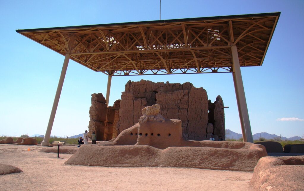
Casa Grande 1100 W Ruins Dr, Coolidge, AZ
The national monument consists of the ruins of multiple structures surrounded by a compound wall constructed by the ancient people of the Hohokam period, who farmed the Gila Valley in the early 13th century. Archeologists have discovered evidence that the ancient Sonoran Desert people who built the Casa Grande also developed wide-scale irrigation farming and extensive trade connections which lasted over a thousand years until about 1450 CE. “Casa Grande” is Spanish for “big house” (Siwañ Wa’a Ki: in O’odham); these names refer to the largest structure on the site, which is what remains of a four-story structure that may have been abandoned by 1450. The structure is made of caliche, and has managed to survive the extreme weather conditions for about seven centuries. The large house consists of outer rooms surrounding an inner structure. The outer rooms are all three stories high, while the inner structure is four stories high. The structures were constructed using traditional adobe processes. The wet adobe is thicker at the base and adds significant strength. Noticeable horizontal cracks define the breaks between courses on the thick outer walls. The process consisted of using damp adobe to form the walls and then waiting for it to dry, and then building it up with more adobe. Casa Grande contained a ball court much like that found at Pueblo Grande de Nevada. Father Eusebio Kino was the first European to view the Hohokam complex in November 1694 and named it Casa Grande. Graffiti from 19th-century passers-by is scratched into its walls; though this is now illegal. Casa Grande now has a distinctive modern roof covering built in 1932.
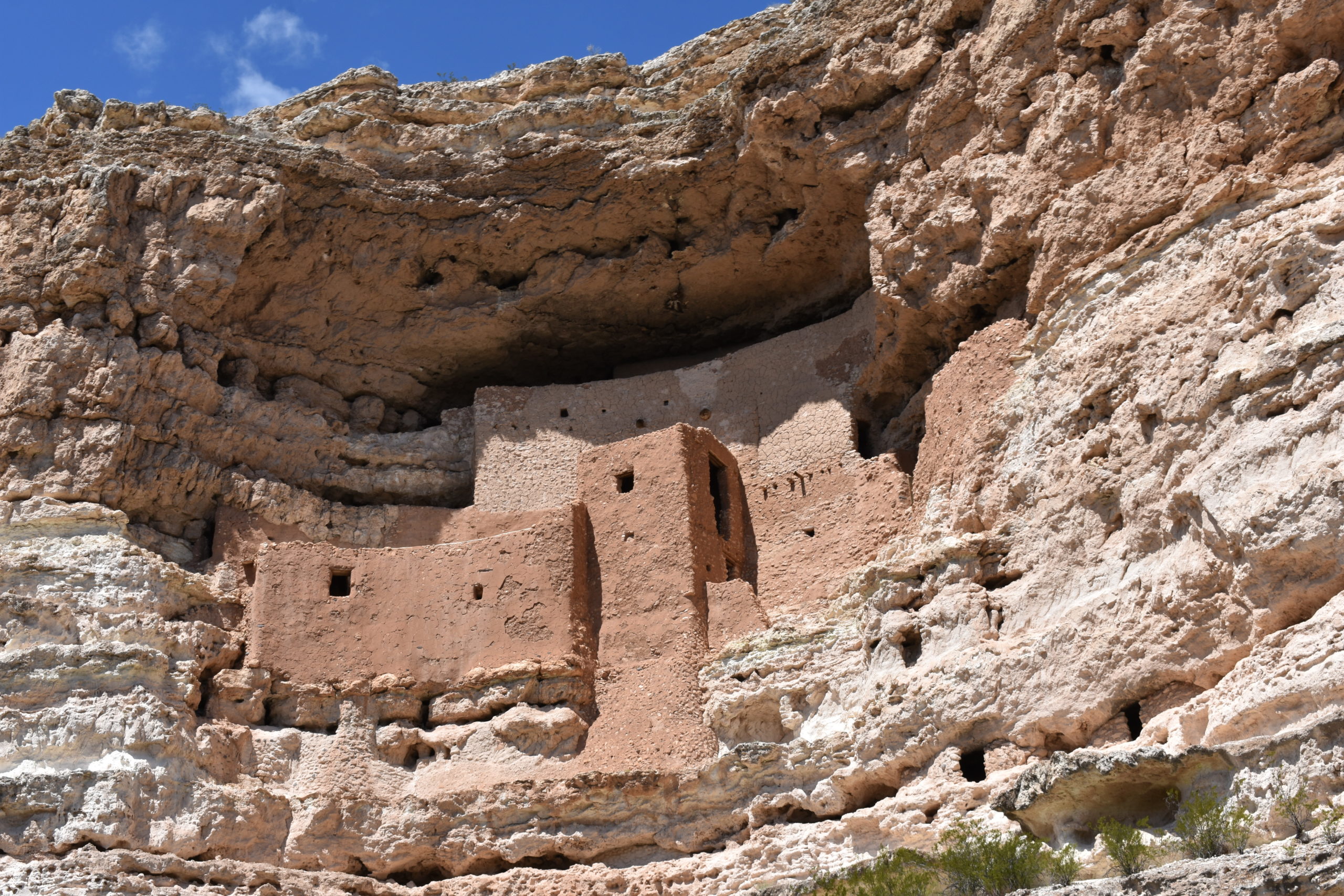
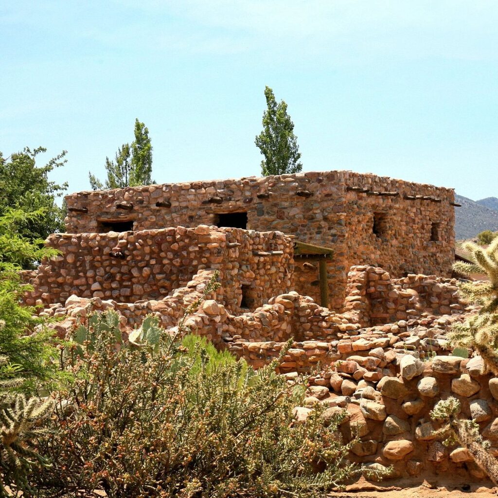
Montezuma Castle Montezuma Castle Rd, Camp Verde, AZ
Montezuma Castle National Monument protects a set of well-preserved dwellings located in Camp Verde, Arizona, which were built and used by the Sinagua people, a pre-Columbian culture closely related to the Hohokam and other indigenous peoples of the southwestern United States, between approximately AD 1100 and 1425. The main structure comprises five stories and about 20 rooms and was built over the course of three centuries.
Several Hopi clans and Yavapai communities trace their ancestries to early immigrants from the Montezuma Castle/Beaver Creek area. Archaeological evidence proves that the Hohokam and Hakataya settled around or in the Verde Valley. Clan members periodically return to these ancestral homes for religious ceremonies.
Montezuma Castle is situated about 90 feet (27 m) up a sheer limestone cliff, facing the adjacent Beaver Creek, which drains into the perennial Verde River just north of Camp Verde. It is one of the best-preserved cliff dwellings in North America, in part because of its ideal placement in a natural alcove that protects it from exposure to the elements. The precariousness of the dwelling’s location and its immense scale of floor space across five stories suggest that the Sinagua were daring builders and skilled engineers. Access into the structure was most likely permitted by a series of portable ladders, which made it difficult for enemy tribes to penetrate the natural defense of the vertical barrier
Wupatki National Monument Flagstaff, AZ
Nestled between the Painted Desert and ponderosa highlands of northern Arizona, Wupatki National Monument is an unlikely landscape for a thriving community. The early 1100’s marked a time of cooler and wetter weather, when the ancestors of contemporary Pueblo communities created a bustling center of trade and culture. For indigenous peoples, these sites represent the footsteps of their ancestors.
The many settlement sites scattered throughout the monument were built by the Ancient Pueblo People, more specifically the Cohonina, Kayenta, and Sinagua. Wupatki, which means “Long Cut House” in the Hopi language, is a multistory pueblo dwelling comprising over 100 rooms and a community room and the northernmost ballcourt ever discovered in North America, creating the largest building site for nearly 50 miles. Nearby secondary structures have also been uncovered, including two kiva-like structures. A major population influx began soon after the eruption of Sunset Crater in the 11th century (between 1040 and 1100), which blanketed the area with volcanic ash, improving agricultural productivity and the soil’s ability to retain water. By 1182, approximately 85 to 100 people lived at Wupatki Pueblo, but by 1225, the site was permanently abandoned. For many years, layers of ash and lava would have made habitation difficult. Based on a careful survey of archaeological sites conducted in the 1980s, an estimated 2,000 people moved into the area during the century following the eruption. Agriculture was based mainly on maize and squash raised on the arid land without irrigation. In the Wupatki site, the residents harvested rainwater due to the rarity of springs.
Kinishba Ruins Whiteriver, AZ
Kinishba is a large pueblo ruin containing nine masonry buildings constructed between 1250 and 1350 A.D. by the pre-Columbian Mogollon culture. The pueblo is situated on the upper end of a grass covered valley and originally had 400-500 ground floor rooms standing two or three stories high. At its peak, Kinishba may have housed up to 1000 occupants. The pueblo was vacated in the late 14th-early 15th centuries for unknown reasons.
The Kinishba pueblo is composed of nine major building mounds, the remains of masonry room blocks, some of which were originally three stories tall. There were two large apartment blocks, and several smaller buildings, with two communal courtyards. At its peak, Kinishba may have housed up to 1,000 to 1,500 people. The masonry walls are unique for their double-walled construction: one side is faced and the other made of rubble. The rooms averaged 14 by 12 feet (4.3 by 3.7 m), with a firepit in the center. Scholars believe that most families occupied two rooms, one for living quarters and one for storage.
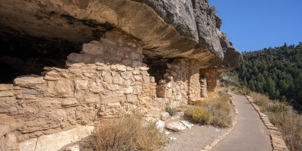
Walnut Canyon National Monument
Walnut Canyon National Monument is a United States National Monument located about 10 mi southeast of downtown Flagstaff, Arizona, near Interstate 40. The canyon rim elevation is 6,690 ft; the canyon’s floor is 350 ft lower
Most of the cliff dwelling rooms are situated near the loop trail, typically slightly above the trail and immediately outside the loop itself. A typical room might have been the dwelling of a single family, and might measure approximately two meters high by six meters long by three meters deep. Because of the area’s dry climate, the water present in the canyon was essential for its inhabitants over 700 years ago as it is for animal and plant life today. The plant life is very diverse in Walnut Canyon, with more than 387 different plant species, including the Prickly Pear cactus and the Arizona Black Walnut. The biodiversity of the area includes high concentrations of sensitive plant species that probably contributed to the decision made by prehistoric people to settle in the area.
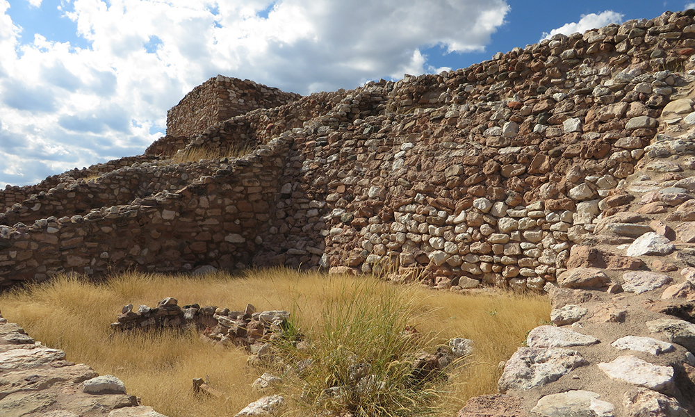
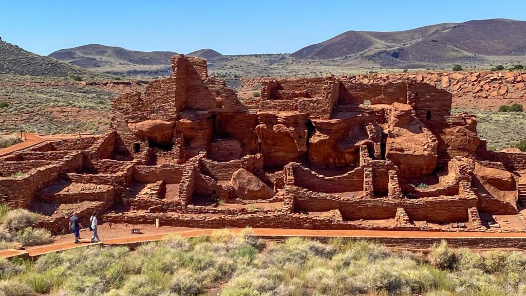
Tuzigoot National Monument Clarkdale, AZ
Tuzigoot National Monument (Yavapai: ʼHaktlakva, Western Apache: Tú Digiz) preserves a 2- to 3-story pueblo ruin on the summit of a limestone and sandstone ridge just east of Clarkdale, Arizona, 120 feet (37 m) above the Verde River floodplain. The Tuzigoot Site is an elongated complex of stone masonry rooms that were built along the spine of a natural outcrop in the Verde Valley. The central rooms stand higher than the others and they appear to have served public functions. The pueblo has 110 rooms.
The people who built and lived in the rooms of the Tuzigoot pueblo were part of a thriving community with trade connections stretching hundreds of miles. Their lives were part of a vast and complex society, and they had a deep and nuanced understanding of the world around them.
The pueblo at Tuzigoot consists of over a hundred rooms, and was probably home to several hundred people for several hundred years. After the people left, sometime in the 1300s, the pueblo stood empty until the early 1930s, when it was excavated by American archeologists and then turned into a national monument on July 25th, 1939.
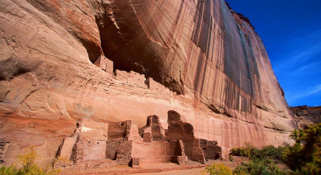
Canyon De Chelly Chinle, AZ
Canyon de Chelly National Monument (/dəˈʃeɪ/ də-SHAY) was established on April 1, 1931, as a unit of the National Park Service. Located in northeastern Arizona, it is within the boundaries of the Navajo Nation and lies in the Four Corners region. Reflecting one of the longest continuously inhabited landscapes of North America, it preserves ruins of the indigenous tribes that lived in the area, from the Ancestral Puebloans (also known as the Anasazi) to the Navajo. The monument covers 83,840 acres (131 sq mi; 339 km2) and encompasses the floors and rims of the three major canyons: de Chelly, del Muerto, and Monument. These canyons were cut by streams with headwaters in the Chuska Mountains just to the east of the monument. None of the land is federally owned. Canyon de Chelly is one of the most visited national monuments in the United States.
Canyon de Chelly is entirely owned by the Navajo Tribal Trust of the Navajo Nation. It is the only National Park Service unit that is owned and cooperatively managed in this manner. About 40 Navajo families live in the park. Access to the canyon floor is restricted, and visitors are allowed to travel in the canyons only when accompanied by a park ranger or an authorized Navajo guide. The only exception to this rule is the White House Ruin Trail, however this trail has been closed until further notice since March 2020.

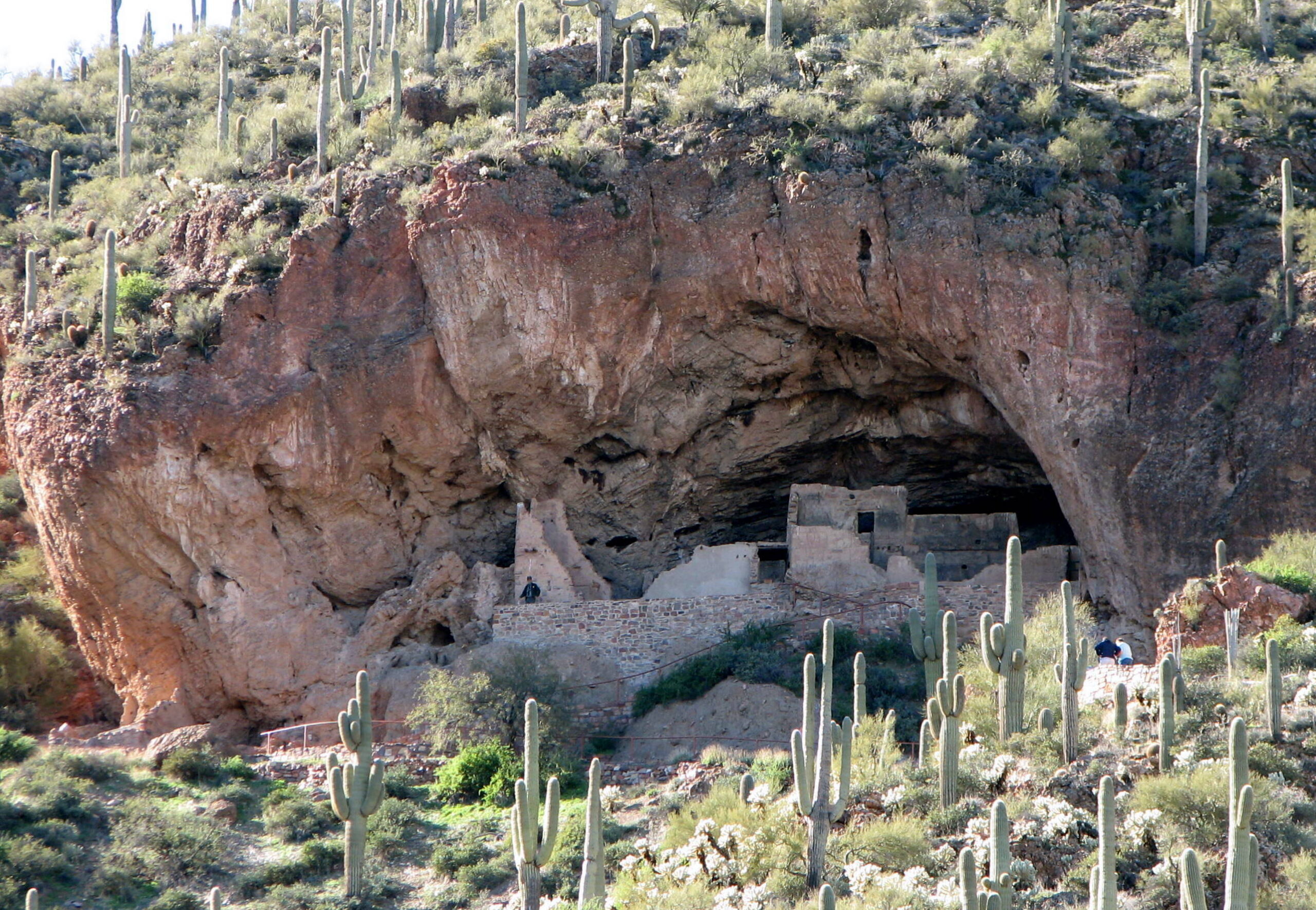
Tonto National Monument 26260 AZ-188, Roosevelt, AZ
Well-preserved cliff dwellings were occupied by the Salado culture during the 13th, 14th, and early 15th centuries. The people farmed in the Salt River Valley, and supplemented their diet by hunting and gathering native plants. The Salado were fine craftspeople, producing some of the most flamboyant polychrome pottery and intricately woven textiles to be found in the Southwest. Some of the artifacts excavated nearby are on display in the visitor center museum.
Tonto National Monument preserves five cliff dwelling sites and numerous smaller sites situated in the Tonto Basin, Arizona. Two of the sites – the Upper and Lower ruins – are accessible to the public via self-guided and ranger-led tours. Both were built by the Salado inhabitants of the region ca. A.D. 1300-1325 and were occupied perhaps as late as A.D. 1450, when the Salado people moved out of the region.
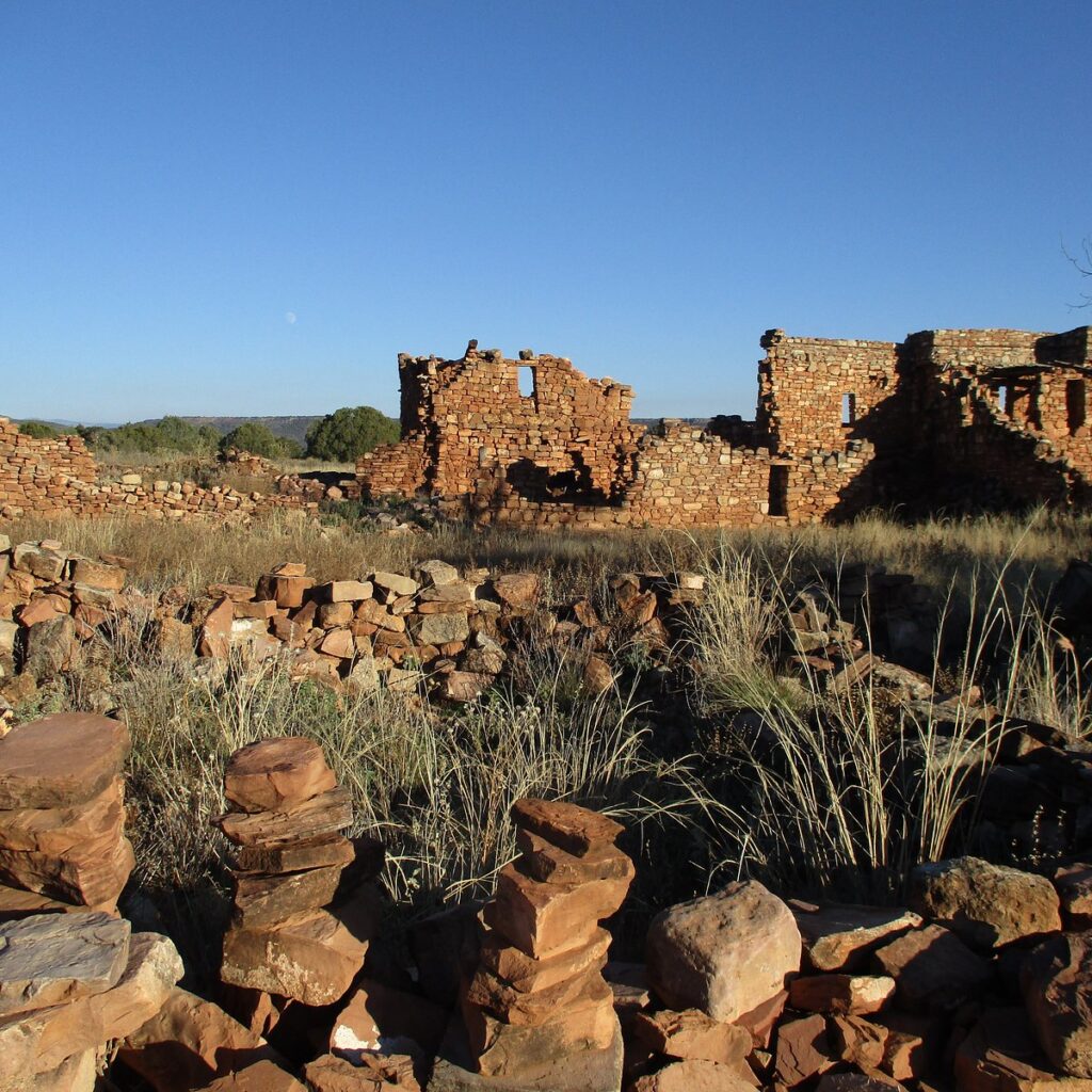
Besh Ba Gowah Globe, AZ
Besh-Ba-Gowah is a 200-room prehistoric Salado masonry pueblo located atop a broad ridge overlooking Pinal Creek. The site is situated one mile southwest from Globe, Arizona and surrounded by a small city park and adjacent museum with excavated items including prehistoric pottery, stone and woven artifacts. The site is operated by the city as Besh Ba Gowah Archaeological Park and Museum.
Besh-Ba-Gowah was occupied by Salado populations between AD 1225 and AD 1400. “Salado” is the term applied to the complex of cultural attributes of the prehistoric peoples who inhabited the Globe/Miami and Tonto Basin regions between AD 1150 and AD 1450.


Inside Arizona 2023 | All Rights Reserved.