We use cookies to help you navigate efficiently and perform certain functions. You will find detailed information about all cookies under each consent category below.
The cookies that are categorized as "Necessary" are stored on your browser as they are essential for enabling the basic functionalities of the site. ...
Necessary cookies are required to enable the basic features of this site, such as providing secure log-in or adjusting your consent preferences. These cookies do not store any personally identifiable data.
Functional cookies help perform certain functionalities like sharing the content of the website on social media platforms, collecting feedback, and other third-party features.
Analytical cookies are used to understand how visitors interact with the website. These cookies help provide information on metrics such as the number of visitors, bounce rate, traffic source, etc.
Performance cookies are used to understand and analyze the key performance indexes of the website which helps in delivering a better user experience for the visitors.
Advertisement cookies are used to provide visitors with customized advertisements based on the pages you visited previously and to analyze the effectiveness of the ad campaigns.
Arizona has a wealth of great places to see, most people have heard of the Grand Canyon, but here is a list of great places to go see that you may have never heard of!
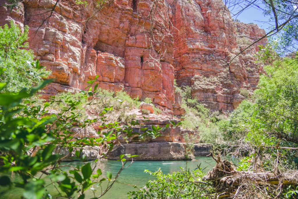
Sycamore Canyon
Sycamore Canyon Wilderness encompasses the second largest canyon in Arizona’s red rock country and was designated a wilderness area in 1972. A lesser known, but equally scenic, cousin of Oak Creek Canyon, Sycamore Canyon Wilderness contains more than 50,000 acres of colorful cliffs, soaring pinnacles, and one of the world’s rarest habitats, a desert riparian area.
Location: About 40 southwest of Flagstaff by roads that start paved and get progressively rougher.
Access: You may get to this area from a number of highways and Forest Service roads. Major access points are off Route 66/FR 231, U.S. 89A, and FR’s 152, 152D, 152C, 525, 538E, 538G and 538H.
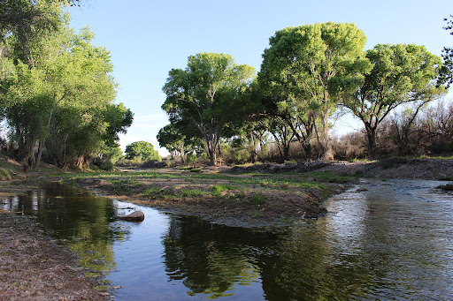
San Pedro Riparian National Conservation Area
The San Pedro Riparian National Conservation Area (NCA) contains almost 57,000 acres of public land in Cochise County, Arizona, between the international border and St. David, Arizona. More than 80 species of mammals, two native species and several introduced species of fish, more than 40 species of amphibians and reptiles, and 100 species of breeding birds call the river home. It also provides invaluable habitat for 250 species of migrant and wintering birds and contains archaeological sites showing remnants of human occupation from 13,000 years ago.
The San Pedro Riparian NCA is 6 miles east of Sierra Vista, Arizona. From Tucson, take Interstate 10 east 40 miles to Arizona Route 90. Follow the highway south through Huachuca City to Fry Boulevard in Sierra Vista. Follow this street for six miles east until you reach the San Pedro House.
Lava River Cave
This mile-long lava tube cave was formed roughly 700,000 years ago by molten rock that erupted from a volcanic vent in nearby Hart Prairie. The top, sides and bottom of the flow cooled and solidified first, after which the insides of the lava river continued to flow emptying out the present cave. Dress appropriately when you come to visit, with warm clothes and sturdy shoes. The cave is as cool as 42° even in summer, and you may even find some ice inside. The rocks are always sharp and slippery, too. Bring two or three sources of light, in case one happens to fail, it can be very dark one mile from the nearest light source.
Drive 9 miles north of Flagstaff on US 180 and turn west (left) on FR 245 (at milepost 230). Continue 3 miles to FR171 and turn south 1 mile to where FR 171B turns left a short distance to Lava River Cave. The road is closed when it’s very muddy or snowy so check first to make sure you can get there.

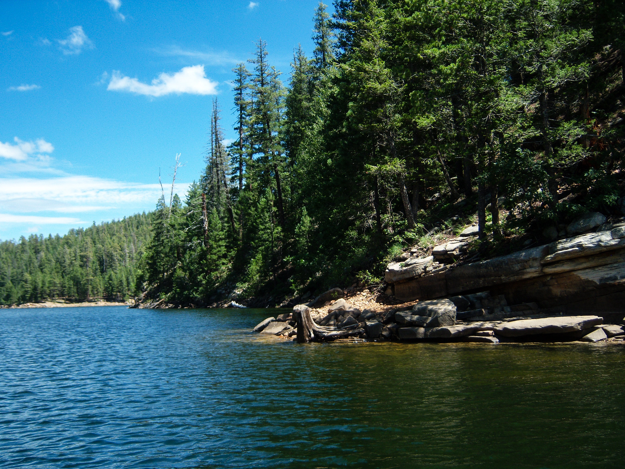
Knoll Lake
This secluded forest lake attracts visitors for a number of reasons. Surrounded by ponderosa pines, with a picturesque island in its middle, Knoll Lake provides a scenic setting in which to enjoy your canoe or other small boat. Fishing is good here too, offering rainbow trout stocked by AGFD.
From Flagstaff take Hwy 3 (Lake Mary Rd) south 55 miles to Clints Well. Turn left (north east) on Hwy 87, go 10 miles to FR 95 which is just past the Blue Ridge office of the Mogollon Rim Ranger District. Turn right and go 6 miles to FR 96 veering left and travel 2 miles to FR 321. Turn right and drive 10 miles to FR 300. Turn left (east) and go 4 miles to FR 295E. Turn left again and drive to Knoll Lake. The road is closed in the winter.
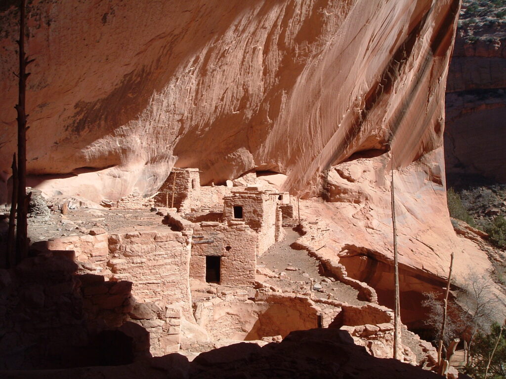
Keet Seel
Keet Seel is an Anasazi cliff dwelling located between Kayenta and Tuba City, Arizona in the Navajo National Monument. The site has one of the best preserved Anasazi cliff dwellings found in the southwest. Getting to Keet Seel requires descending from the mesa at Tsegi Point into the canyons of the Navajo Nation Indian Reservation. Once in the canyons hikers follow a marked route with numerous stream crossings and several waterfalls until they arrive at a Ranger Station just below the ruin. A Park Ranger will then take them on a guided tour of the site. Visitors must sign the sheet for the day and obtain a permit, which is available for free after taking part in a special orientation, before being allowed to enter the canyon. Those that would like to split the long journey over a 2 day period can backpack in and stay at the campground located near the site. This is a long strenuous hike and only limited availability, 25 people a day.
From downtown Flagstaff, go north on U.S. Route 89 for 66.1 miles to U.S. Route 160. Turn right onto U.S. 160 and continue 62.7 miles to State Route 564. Turn left onto SR 564 and continue 9 miles to the Navajo National Monument entrance. From there, continue another 0.3 miles to the visitors center.
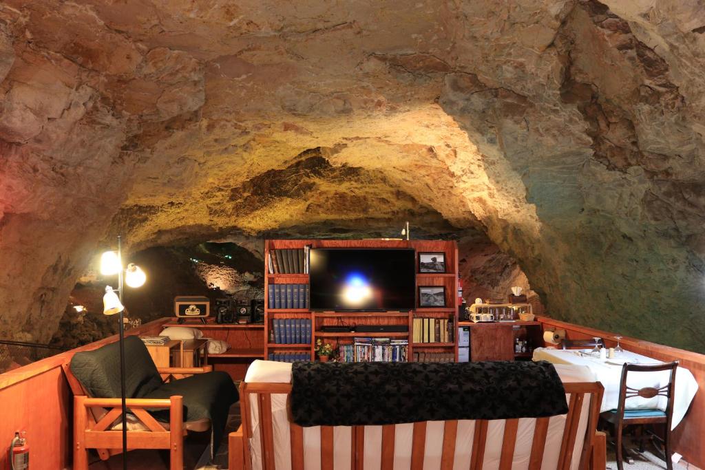
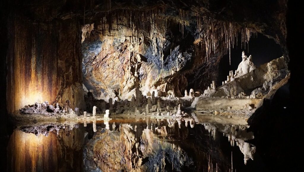
Grand Canyon Caverns Inn
Take in the awe inspiring Grand Canyon Caverns located along Route 66 in Northern Arizona. These are the largest dry caverns in the United States, located 200 to 300 feet below the surface, and accessible via the exploration elevator. Located in the middle of 3,000,000 acres of the most unspoiled land left in the world, enjoy clean air, clear skies, open prairies, and a refreshing change of scenery from the urban world. They feature cavern tours that are easily accessible along paved walkways with handrails and for the more adventurous, off-path ‘Explorers Tours’.
From Kingman (heading East on I40), exit Interstate 40 at the Route 66 exit (Andy Devine Blvd.). Take Rt. 66 northeast about 65 miles. A few miles past Peach Springs and you’re at the Grand Canyon Caverns & Inn.
From Seligman (heading West on I40), exit Interstate 40 and take Rt. 66 about 22 miles northwest to Grand Canyon Caverns & Inn.
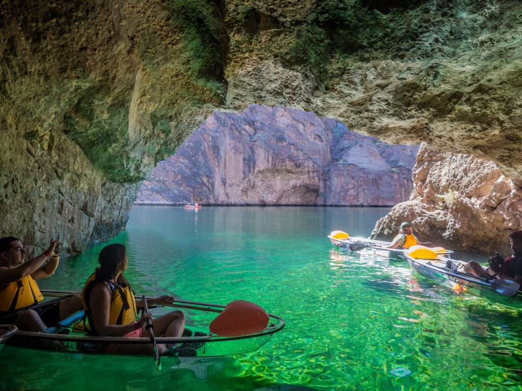
Emerald Cave
The Emerald Cave owes its unique green color to a combination of factors, including the sunlight that reflects off the water and the minerals that are present in the surrounding rocks. The cave is also fed by underground springs that bring in fresh water, which is filtered through layers of limestone and other minerals, giving it a distinct color and clarity.
The Black Canyon, where the Emerald Cave is located, is a deep and narrow gorge that was formed over millions of years by the erosive power of the Colorado River. The canyon walls are made up of layers of volcanic rock and limestone, which have been exposed and weathered over time, creating unique patterns and textures.
If you’re looking for a short day trip, your best option is to kayak from Willow Beach to Emerald Cave. Willow Beach is an access point in Lake Mead Recreation area on the Arizona side of the river (entry fee required). The beach is 2 miles downstream of the cave, so you’ll paddle 4 miles total.
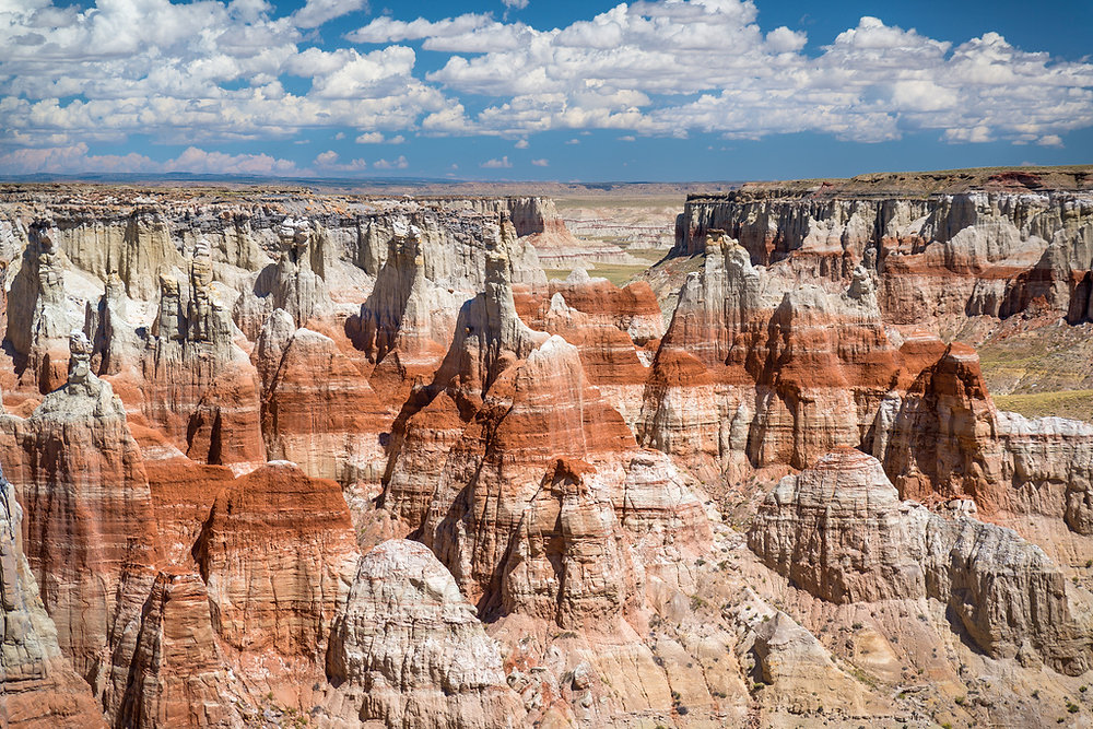
Coal Mine Canyon
On the border between the Hopi and Navajo Reservations in the vast desert of northeast Arizona, Coal Mine Canyon is a long way from any famous attraction and is not signposted in any way yet has become quite well known because of the amazingly colorful formations that line the upper end of the ravine.
The canyon is one of many remote, little-visited sites in the Southwest where the main interest comes from the detail of the rock – the colors, forms and textures of the eroded sandstone.
The canyon is accessed from highway 264 between Tuba City and Old Oraibi – a little used road that forks south off the much busier US 160, winds across the wide valley of Moenkopi Wash then climbs to the top of a flat, featureless, grassy plateau (Coal Mine Mesa), reminiscent of the endless Llano Estacado of New Mexico and the Texas Panhandle. Mesa and canyon are named on account of the thin, low grade deposits of coal that are found scattered across the area, and are prominently visible in parts of the upper canyon. Occasional dwellings dot the landscape, at the end of sandy side tracks, but otherwise the land is unchanging, the road straight and empty.


Inside Arizona 2023 | All Rights Reserved.